GPS Tracks are simply a sequence of coordintates stored together that can be followed in the field using a hand held device (Such as a Smartphone!!) or displayed in mapping software/websites to plan a hike and create a paper map. Of course caltopo can read/display/import this data as well as write/export. I currently use GaiaGPS on my iPhone as a portable, in the field, GPS device. Although there are several formats for the files that contain GPS data, I have found that .gpx files work in sharing data between caltopo and GaiaGPS.
For you tech types, .gpx files are XML. So they can easily be read with any text editor. This would be yet another way of obtaining coordintates if you found a .gpx file that you want to use. However, you can manage the same thing by importing the file into caltopo and just putting your cursor over an intersting portion of the track.
Use the buttons on the same toolbar as the search box to import and export .gpx track files:
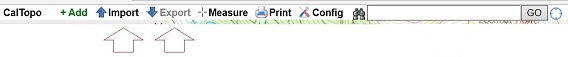
Use the Annette Lake GPX file or any .gpx file to follow along. Download your chosen file to a directory on your computer. (If you simply click on the Annette GPX link, likely your browser will display the XML format and you will see the Lat/Lon values. To save the file on your computer, right click on a PC and choose Save Link/Traget As...) Then click the import button on the caltopo toolbar and choose your file. On the left side of the caltopo screen, an entry should appear under Lines & Polygons. If so, then you should be able to click on it and the map will move and adjust to show your gps track. If all went well, you will have a (likely) red line drawn on your map that is the gpx track you imported.
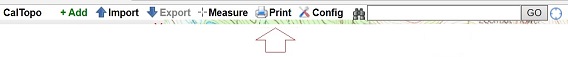
This track can now be edited and modified in a number of ways that are beyond the scope of this discussion. I leave it to you to learn caltopo as you see fit. Once you have modified your track to you liking you can export it and/or print it. The print button is also on the toolbar.
There are some notes here about printing a map in caltopo.
Finally, some more notes about accuracy. If you imported the gpx track I referenced here on top of the USGS map (which is the default) you will note that the track does not seem to follow the trail. This can be for a lot of reasons. In this case the USGS data is likely old. It was on this trail that I learned the hard way not to rely solely on gps data. I wrote up the story here: Silver Peak, 1/10/16
The Silver Peak article referenced above talks about different maps that are available in caltopo. In the upper right corner of caltopo, just above the coordintates there is a display control for the layers, maps and overlays. Mouse over this and it will expand. Pull down the dropdown box labled "Base Layer" at the top of the list. My only advice is to experiment with these.
Back in this tutorial to Finding Coordinates
Next in this tutorial to GPS Tracks in the Field