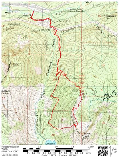
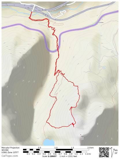
Edit: At Steve McClure's suggestion, I have our track on the Open Cycle Map (both of these overlays are done with CalTopo.com) as a comparison to the USGS. On the Open Cycle, the trail proceeds southbound from the top of the last switch back on our track. This agrees with my experience of having hiked this trail several times without snow on it. On the USGS, there are far fewer switchbacks, they start lower and a bit to the south of the existin switchbacks.
|
|
We set out on a winter scramble of Silver Peak. Our leader had done this trip in winter several times before. We encountered snow right at the trailhead and set off following the beaten path that roughly followed the trail to Annette Lake. I have hiked this trail several times and I could tell that the beaten track was not accurately following the actual trail all of the time but it was mostly right on it. About halfway along the southbound trail, there is a set of switch backs and when we got to the top of these we left the trail to scramble up to the ridge leading to the peak. After summiting, we discussed the possibility of making a loop by descending straight down the other side of the ridge and ending up very close to Annette Lake. With the avalanche danger low and the lack of a strong wind, this route seemed to be the fastest as we could do a rapid plunge step descent. The biggest risk seemed to be not finding the trail or a beaten path at the bottom of the slope. I told the group that I had Gaia GPS on my phone, I was tracking our trip on it and that I could see the trail on the USGS map in the app. This satisfied everyone and we did a 1400' descent in about 15 minutes. It was a hoot!
When we reached the trees at the bottom on the avalanche chute. The GPS indicated we were still about 250' above the trail. We kept going down through the woods until we found a beaten path right about where the app indicated it should be. Everything made sense, so we set out to follow the "trail" out. After about 30 minutes, the going got rough and it seemed like the tracks were leading us off the trail. I consulted Gaia again and were about 200' above the trail indicated on the USGS. So I let everyone we should descend again and we went straight down the fall line to get to the right elevation. We soon realized we were on the wrong side of a large gully and there was no easy way to cross in sight. I know this trail well enough to know there is no gully crossing this difficult. Several other phones came out to check this against my phone and they all showed the same thing… the trail was supposed to be below us. However, the gully crossing was only getting worse below us. We decided to cross the gully while we still could and just strike out to pick up our track north of us as I had recorded earlier.
So what went wrong? Clearly the trail was not where the app indicated it should be, and my app was not the only one that indicated we should have descended farther where the gully crossing was going to be even worse. It dawned on us that the trail indicated on the USGS must be old. In fact the very gully we were trying to cross may have been created by a slide since the map was made and causing the trail to be rerouted. So the lesson here is that the map data Gaia uses may be old. The USGS quads are largely from 1983 and some are as old as 1927.
As for the outcome of the day, it was dark by the time we crossed the big gully. We put on head lamps and set out to the north staying roughly at the same elevation. I had well over 1/2 battery life on my phone so I knew I could keep using it for hours. It took us well over an hour to travel half a mile to the track, but we found the beaten down path right at the switch backs I mentioned earlier… right where Gaia on my phone indicated that it should be.
In conclusion we had several smart phones with a couple of different apps available to for use as GPS. They were all obviously using the same outdated information, which is not surprising as the USGS has been the standard for such apps. My phone was the only one recording our track for the day so we were using it as our primary GPS. Any of the other phones would have helped us find our way out. We were not depending on just the one phone. In fact we were not lost. We all knew we just needed to go due north and we would have found our way out. The only real gain was to find the most efficient way out. As it was I tracked our day at just under 12 hours. Based on our progress in the dark when we were off trail vs on trail I estimate we saved as much as 2 hours or even more had we made another serious mistake. In this case, Gaia GPS both led us astray and helped get us out of a jam. When our route was no longer making sense we started to question. When using the GPS to find our way back to the trail just made things worse, we questioned some more. We did not abandon the GPS as a tool at that point but rather decided that some portion of the information it provided, the location of the trail, was incorrect. That did not mean all the information was incorrect. We used other methods of navigation as well such as following a contour line by neither ascending nor descending as we traveled to our destination. That is, the track recorded early that day.