Decimal Degrees latitude and longitude
47.3929, -121.4738
Degrees Minutes Seconds latitude and longitude
47°23'34", -121°28'26"
Univeral Transverse Mercator
10T 0615174E 5249952N
How do we find GPS coordinates in the first place? 1) You might find them included on trip reports. 2) You can estimate them on a map from the grid formed by coordinates printed on the edges and the lines (real or imaginary) that connect them. 3) Finally, you can visually locate a point of interest with mapping software/websites and read off the coordinates that correspond to the mouse cursor.
Getting coordinates from trip reports etc
Now that you know what GPS coordinates look like, (see the Annette Lake Trailhead coordinates to the right) you might start to notice them on trip report pages and other information about a trail of interest from the Internet.
Getting coordinates from a map
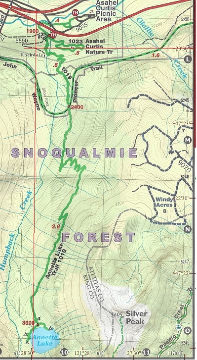
Another method would be to estimate the coordinates from the grid drawn or implied on a printed map. The example below shows a Green Trails map of the Annette Lake hike. I added the red lines that cross at aproximately 47 degrees 23 minutes 30 seconds, -121 degrees 28 minutes 30 seconds. Compare this to the Degrees Minutes Seconds I have provided for the TH in the box on the right. It is pretty close, but not quite right. It is important not to get too concerned about the degree of accuracy implied by some of these numbers. Should the TH mark be to the left or right of the vertical red line? Can you see that my coordinates do not really match the map? Does it really matter? I would suggest this information presented here is good enough for me to find the trail.
Take some extra time to study this example. You should be able to work out the UTM coordinates for the trailhead as well.
Paper maps are great for in the field. You should never go on a hike without one. For doing the research on where to go hiking and even printing your own paper maps, there is software and web sites that can tie this all together. For this discussion, I will introduce caltopo.com. It is free to get started. (There are some things for which they charge money that you will not need for now, but consider giving these folks some money if you use the site a lot. We do not want them to disappear for lack of funds!)
Getting coordinates from Caltopo
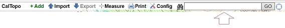
We can use caltopo to find GPS coordinates by "scrolling around" on the map until we can put the mouse cursor over the spot we want. Or we can enter the coordinates we have and caltopo will display the map for that location. In either case the starting point is the search box. This is found near the top of the caltopo.com page. See the picture below. Type in a landmark, city or geographical feature that you know to be close. Try entering "Snoqualmie Pass", then enter.
Annette Lake will likely be off of your screen to the southwest. (down and to the left. To "scroll" the map such that the lake and trail will be visible, click somewhere on the map (the middle should work), and "drag" up and to the right. By default, caltopo displays the USGS maps, so this may look different than the Green Trails map clipping I have included here. However, it should not be too difficult to spot the trailhead as you compare the two maps. Once you have found the trailhead, move your mouse curser over that spot and look in the upper right corner of caltopo and you should see the coordinates in Decimal degrees and UTM format.
It is also possible to enter coordinates in the search box. To demonstrate this, send caltopo off to a location far off the current map. Perhaps put Mt Rainer in the search box (and enter). Now that Annette Lake is no longer on the map, put "47 23 30, -121 28 30" (without the quotes) in the caltopo search and you will go right back to Annette Lake trailhead. This is the same Degrees Minutes Seconds that we estimated from using the coordinate grid on the Green Trails.
This reveals a wonderful implication of caltopo. Use it to convert coordinates of one system to another. Input the coordinates you want converted in the search box, move the mouse over the feature you want and read off the coordinates in Decimal Degreeds or UTM. If you really want the coordinates in Degrees Minutes Seconds, then right click on the point in caltopo and select "point info" --> "position and elevation".
Back in this tutorial to Coordinate Systems
Next in this tutorial to GPS Tracks