The Complete Track
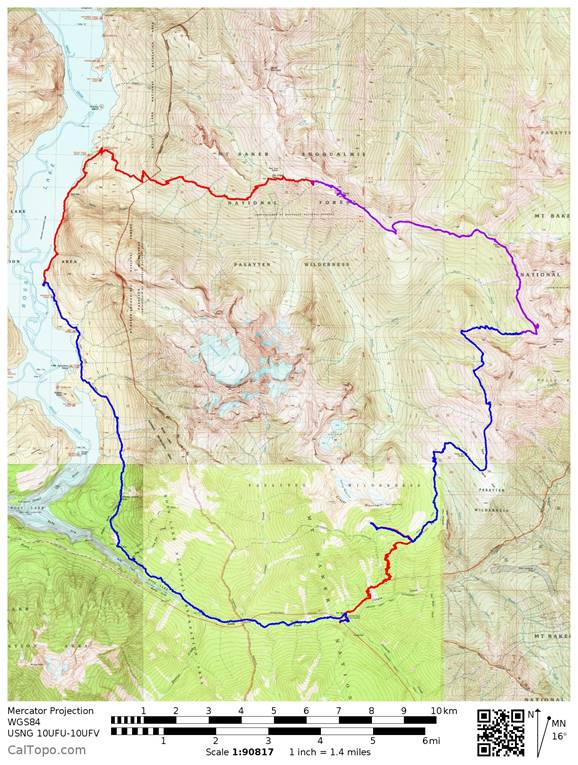
August 2-6, 2016
51 miles
12,000' elevation gain
Smartphone battery strategies while backpacking
When using a Smartphone as a GPS in the field, there are several usage modes. Selection of mode is determined by a number of factors. Battery life is one. On an extended backpacking trip like this one, battery life is critical.
There are two basic strategies for dealing with battery life.
- Minimize the use of the GPS.
To do this, pre-load the required maps. Create a route/waypoints either manually or by importing a .gpx file. Turn the phone on only when needed to get a fix on position. - Bring extra batteries and run a continuous track.
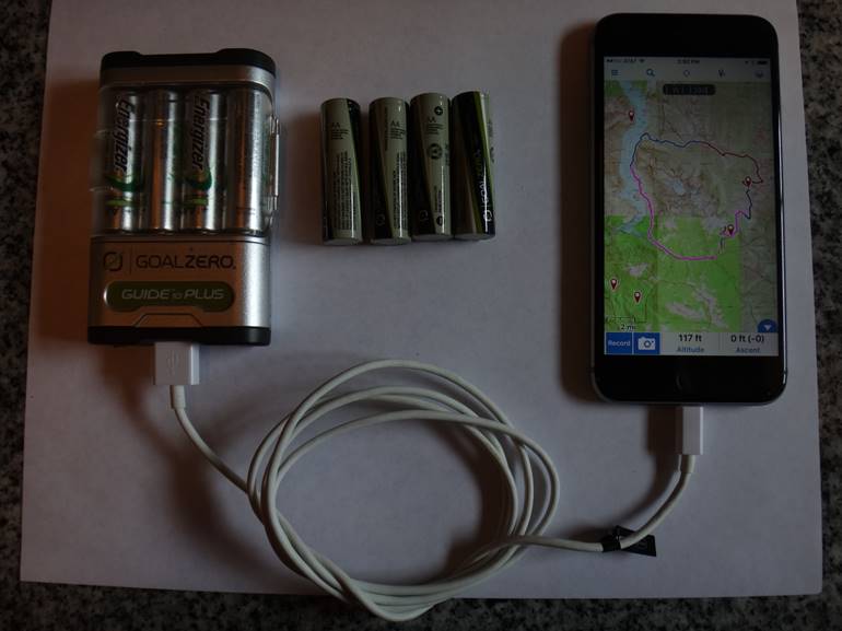
One of the biggest criticisms of the iPhone has always been a lackof user replaceable battery. On my old iPhone 4s, I could only run a track for 3-4 hours before completely depleting the internalbattery. On this trip I was running tracks for an average of 6 hours per day and using approximately 25% of the battery on my iPhone 6s. This agrees with an earlier experience when I ran a continuous track for12 hours and used approximately 50% of the battery life.
For this 5-day backpack, I brought a GoalZero battery pack and multiple sets of rechargeable AA batteries. It is important to note that on my iPhone, I cannot charge it with regular Alkaline orLithium batteries, I must use rechargeable. The first set of batteries Iused was able to charge the phone to nearly full 3 times. In each case,the phone indicated a charge of about 70%. The implication being that I could get about 7 days of 6 hour tracks from the phone (4 days) and one set of batteries (3 days).
Of course, your mileage may vary! Different phone manufacturers’ batteries will yield different results and using a phone with a replaceable battery may be better still. There are ways to maximize both your phone battery and the power transfer from battery pack to phone. Throughout the trip, I made it a point to charge the phone in the evening and shut it down when done rather than leave it plugged all night. I noticed that the rate at which it charged slowed down it approached about 97%. Then today, I found this link in my facebook confirming a few things I was beginning to suspect:
you've been charging your smartphone wrong
My choice to run a full track has less to do with navigation and more to do with data collection. Particularly when on trail,traveling a well-known route, there should be little need to look at a GPSmore than once or twice per day. Just know, however, that turning your phone on and off like this means that it will take time on each occasion for the phone to come on and for the app to location your position. This is particularly true if the phone/app is set to look for cell towers before giving up and using the GPS satellites. Onthe iPhone with GaiaGPS (and probably others), putting the phone in Airplane Mode will shorten the time it takes to get a location from the satellites. Look here for a more in-depth explanation of cell tower based vsatellite based location systems.
The data collected when a full track is recorded can includemileage, elevation gain/loss, hiking time, speed etc. Here is some of the raw data from this trip:
| Mileage | Elevation Gain GaiaGPS | Elevation Loss GaiaGPS | |
|---|---|---|---|
| Day 1 | 7.2 | 4063 | 390 |
| Day 2a (We took a 2 hour break to dry our gear, so I shut down the phone during this time) | 5.21 | 1198 | 1097 |
| Day 2b | 5.61 | 2166 | 2149 |
| Day 3 | 9.21 | 2037 | 1620 |
| Day 4 | 10.36 | 235 | 4846 |
| Day 5 | 13.66 | 2341 | 1983 |
| Total | 51.25 | 12,040 | 12,085 |
A bit less obvious is that discrepancies between map source data and actual trail routes can come to light. Often times the underlying data for a GPS' map is the USGS data. Some of this it getting quite old and in some cases, the trails have moved. Some implications and what we might do with this information will bthe topic of the next section.
Changes to the Trail
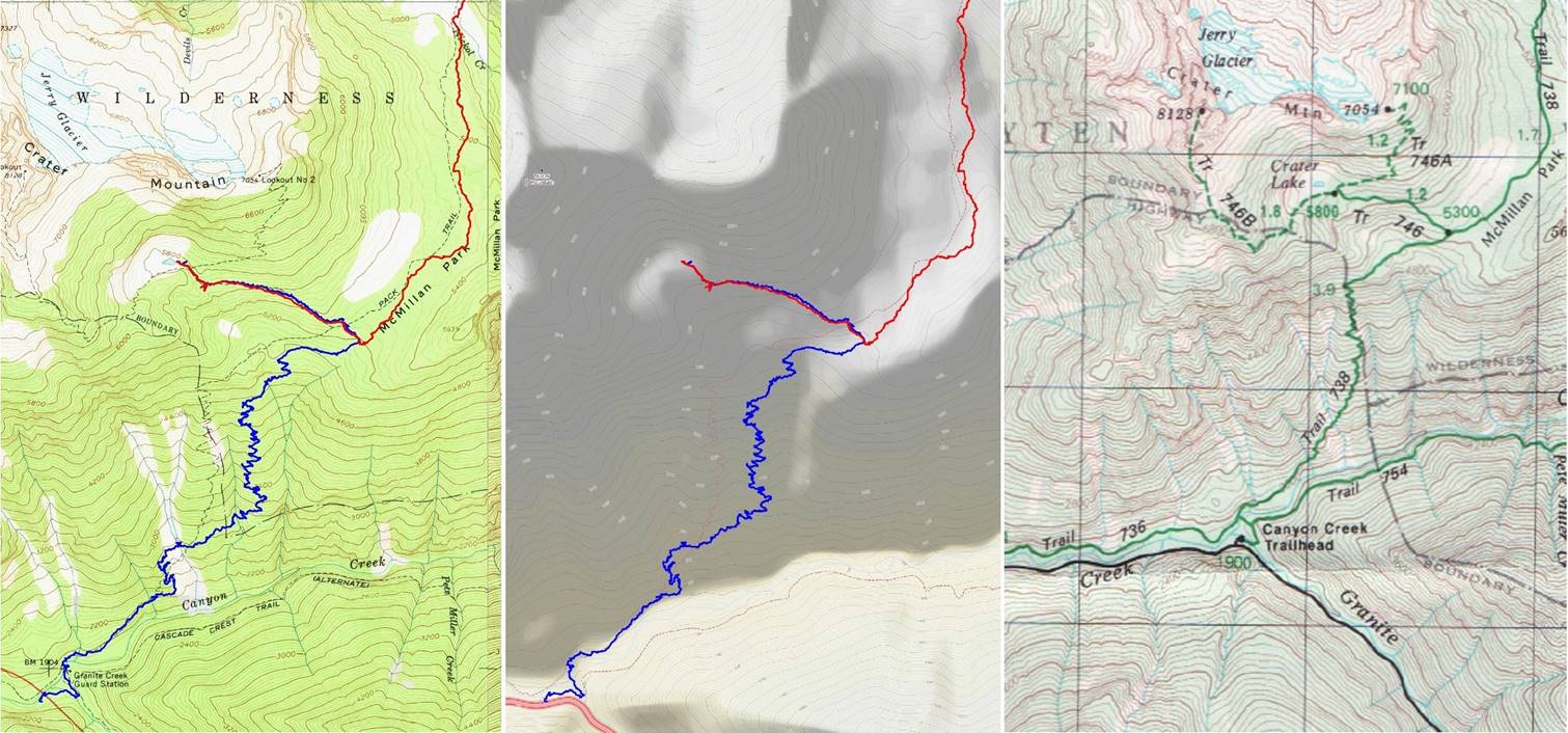
The USGS data is the definitive source for hikers and other backcountry enthusiasts, right? For topographical data expressedin contour lines, this may be so, but for trail placement data, it is possible for it to get out of date. The first time I came acrossthis issue, I was on a scramble to Silver Peak and found, on the wayback, that the Annette Lake trail had been moved since the USGS map had been created. (Read the full storyhere.) In the case of Annette Lake, the Open Cycle data shows the newtrail as it exists today. This is because the Open Cycle data is “Crowd Sourced”. Someone obviously submitted updated data.
In the maps above, the USGS (left) and the Open Cycle (middle)maps both show the trail (dotted lines) to be to the left of the track (blue line for day one and red for day 2) I recorded on the bigclimb to and through McMillan Park. These two pictures are captured from CalTopo.com after importing the data from my phone. On the rightis a scanned image of the Green Trails Map for the same area. I am ofthe opinion that the Open Cycle and Green Trails maps are both usingthe USGS data to show where the trail is. Furthermore, I believe themall to be incorrect since the trail has been moved.
Now it is possible that the GPS track I captured is wrong. There are a number of factors that can throw GPS data off, including atmospheric conditions and canyon walls. However, I do not believe that is the case here. We were definitely not in a canyon on either the hike up on day one nor the hike through McMillan Park on day two. My backpacking companion hiked this trail 30 years ago and definitely remembers a number of key differences. She does not remember crossing the second stream (waterfall) at 4600 ft and she remembers entering McMillan Park at one end and walking through the middle of it. When we hiked it, the trail is clearly off to one side of the Park. In fact, the park looked wet and boggy, which may account for the re-route of the that part of the trail. Finally, the intersection of trails 738 and 746 is shown to be at 5300’ according to the contour lines of the USGS and the notation of elevation at the intersection on the Green Trails map. While the intersection as it exists today is at 5200 ft.
The date on my Green Trails map (latest revision) is 2003. I do not know how to find the map date for a particular USGS map in CalTopo. Presumably there is little to be done for getting the trail data updated on the USGS. The Green Trails will likely be updated at some point. The Open Cycle, though is another story. Because it is crowd sourced, it can presumably be updated much sooner than the other maps.