Northeast Washington Fire Lookouts comments
Stats without AWS Adjustments
| Total Sites: | 97 | Sites with Structures: | 11 |
| Kari has visited: | 5 | Kari has visited: | 5 |
| Dave has visited: | 5 | Dave has visited: | 5 |
| Lookout Name | Kari | Dave | Comments |
|---|---|---|---|
| Abercrombie Mtn. | |||
| Addy Mtn. | |||
| Aladdin Mtn. Lookout | |||
| Baldy (Currant) | |||
| Bead Lake Lookout | |||
| Boundary Mtn. | |||
| Boyer Mtn. Lookout | |||
| Calispell Peak Lookout | |||
| Cee Cee Ah (CCA) Peak Lookout | |||
| Chewelah Peak Lookout | |||
| Churchill Mtn. Lookout | |||
| Cliff Ridge Lookout | |||
| Cooks Mtn. Lookout | |||
| Crowell Ridge Lookout | |||
| Dave Kresek's Lookout | |||
| Diamond Peak Lookout(structure exists) | 48.63244,-117.07886 | ||
| Dry Canyon | |||
| Eagle Mtn. | |||
| Electric Point | |||
| First Thought Lookout | |||
| Flagstaff Mtn. Lookout | |||
| Fosback Lookout | |||
| Fourth of July | |||
| Frisco Mtn. | |||
| Gibraltar Rock Lookout | |||
| Gleason Mtn. Lookout | |||
| Goddards Peak | |||
| Gold Mtn. | |||
| Goose Creek Lookout | |||
| Granite Peak Lookout | |||
| Grassy Top | |||
| Green Mtn. | |||
| Grouse Knob | |||
| Hall Mtn. Lookout | |||
| Hanks | |||
| Hanlon Mtn. | |||
| Harvey Creek | |||
| High Rock | |||
| Huckleberry Mtn. Lookout | |||
| Indian Mtn. Lookout (structure exists) | 48.66267,-117.03929 | ||
| Jackson Mtn. Lookout | |||
| Kalispell Rock | |||
| Kings Mtn. Lookout | |||
| Leadpoint Mtn. | |||
| Leola Peak | |||
| Linton Mtn. | |||
| Little Blue Grouse | |||
| Lookout Point Lookout (structure exists) | X | X | 47.81320,-117.51093 GPS Track This lookout is at the end of a gated community north of Spokane. My track starts where the pavement ends. |
| Mica Peak | |||
| Mill Creek Point Lookout | |||
| Miller Mtn. | |||
| Mineral Mtn. Lookout | |||
| Molybdenite Mtn. Lookout | |||
| Monumental Mtn. (Pend Oreille Co.) Lookout | |||
| Monumental Mtn. (Stevens Co.) Lookout | |||
| Moon Hill | |||
| Nelson Peak | |||
| No Name Peak Lookout | |||
| North Baldy Lookout | |||
| Ojibway Knoll | |||
| Old Dominion Lookout | |||
| Onion Mtn. | |||
| Orwig Hump Lookout | |||
| Pass Creek Ridge | |||
| Pelke Divide | |||
| Prouty Peak | |||
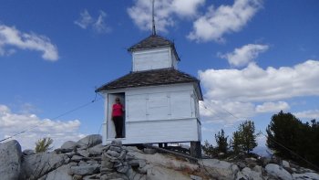
| Quartz Mtn. Lookout (structure exists) | X | X | 47.88521,-117.08210 GPS Track This is part of Mount Spokane State Park. The trail starts from the cross country ski area parking lot. There are big map signs of the ski trails and include a location of the lookout. Find your way to Nova Hut and there are even signs explicitly for the lookout from there. |
| Rogers Mtn. Lookout | |||
| Roundtop Mtn. Lookout | |||
| Russian Ridge | |||
| Saddle Mtn. Lookout | |||
| Salmo Mtn. Lookout (structure exists) | 48.96836,-117.10308 | ||
| Sand Creek | |||
| Scoop Mtn. | |||
| Scrabbler Mtn. | |||
| Shedroof Mtn. Lookout | |||
| Sherwood Mtn. Lookout | |||
| Skookum Peak | |||
| Slate Creek | |||
| Slumber Mtn. Lookout | |||
| Snyder Hill Lookout | |||
| South Baldy Lookout(structure exists) | 48.42343,-117.13743 | ||
| South Fork Mtn. | |||
| Spirit Point | |||
| Spokane Mtn. | |||
| Mount Spokane (vista house)(structure exists) | X | X | 47.92145,-117.11405 See the Quartz Mtn GPS track for a map that includes Mount Spokane within the Mount Spokane State Park. Vista House is at the top of the ski lifts for the downhill ski area. It is a stone structure obviously in use as a warming hut for the skiers. In the summer you can drive all the way up on a paved road. |
| Squaw Valley | |||
| Stranger Mtn. Lookout | |||
| Sullivan Mtn. Lookout (structure exists) | 48.87781,-117.24893 | ||
| Swede Pass Lookout | |||
| Thomas Mtn. | |||
| Thunder Mtn. Lookout | |||
| Timber Mtn. Lookout (structure exists) | 48.52713,-117.45263 | ||
| Tower Mtn. Lookout (structure exists) | X | X | 47.98998,-118.14701 GPS Track This road may be drivable sometimes, but we were stopped by a combination of mud puddles, deep ruts and one downed tree. |
| Turnbull | |||
| Wellpinit Mtn. Lookout (structure exists) | X | X | 47.88661,-118.02080 This one is a drive up, but just barely in a low clearance vehicle |
| Winchester Peak | |||
| Yocum Lake |