There are a lot of structures in this zone. I suppose it is still more prone to fires and I know some of these are still manned.
There are 3 "twofers" in this area: Leecher, North Twentymile and Whitmore. Yet on some lists, North Twentymile does not count as two. The only explanation I have is that the two existing structures occupy effectively the same site. They are very close together. Leecher and Whitmore's structures are farther apart, yet occupy, in my mind, the same peak. For now, we are counting all three sites as having two structures. So that means we are now seeking 94 structures and not 93
Stats without AWS Adjustments
| Total Sites: | 101 | Sites with Structures: | 32 |
| Kari has visited: | 20 | Kari has visited: | 20 |
| Dave has visited: | 17 | Dave has visited: | 17 |
| Lookout Name | Kari | Dave | Comments |
|---|---|---|---|
| Aeneas Lookout (structure exists) | 48.743015, -119.622164 | ||
| Annie | |||
| Armstrong Mtn. Lookout (structure exists) | X | X | 48.26717, -119.08576 We drove to this LO on 5/25/19 |
| Bailey Mtn. | |||
| Barnaby Butte | |||
| Big Hill (Woodpile) | |||
| Bisbee Mtn. | |||
| Black Ridge | |||
| Blue Goat Mtn. | |||
| Bodie Mtn. Lookout | |||
| Bonaparte (structure exists) | X | 48.78512, -119.122057 | |
| Bridge Creek | |||
| Buck Mtn. Lookout (structure exists) | X | X | 48.4366, -119.8227 |
| Buckhorn Mtn. Lookout | |||
| Bunker Hill Lookout | |||
| Burch Mtn. Lookout | |||
| Buttermilk Butte Lookout | |||
| Chiliwist Butte Lookout | |||
| Cody Butte Lookout (structure exists) | 48.34129, -118.6624 | ||
| Columbia Mtn. Lookout (structure exists) | 48.62044, -118.482093 | ||
| Cooper Mtn. Lookout | |||
| Copper Butte Lookout | |||
| Cornell Butte Lookout (structure exists) | 48.59433, -118.8904 | ||
| Corral Butte Lookout | |||
| Defiance Point Lookout | |||
| Diamond Point Lookout | |||
| Doe Mtn. | |||
| Dollarwatch Mtn. Lookout | |||
| Driveway Butte Lookout | |||
| Dugout Mtn. Lookout | |||
| Fir Mtn. | |||
| First Butte Lookout (structure exists) | X | X | 48.6192, -120.1076 GPS Track |
| Franson Peak Lookout (structure exists) | 48.85582, -118.63231 | ||
| Funk Mtn. Lookout (structure exists) | X | X | 48.5997, -119.7434 GPS Track |
| Gardner Mtn. | |||
| Goat Mtn. | |||
| Goat Peak Lookout (structure exists) | X | X | 48.6321, -120.4027GPS Track |
| Gold Mtn. Lookout (structure exists) | 48.18075, -118.46677 | ||
| Gold Ridge | |||
| Granite Mtn. Lookout | |||
| Graves Mtn. Lookout | |||
| Grizzly Mtn. Lookout (structure exists) | 48.41936, -118.4992 | ||
| Hull | |||
| Jackass Butte Lookout | |||
| Jackknife Mtn. | |||
| Johnny George Mtn. Lookout (structure exists) | 47.9111, -118.44348 | ||
| Juniper Point Lookout | |||
| Keller Butte Lookout (structure exists) | 48.06149, -118.79549 | ||
| Knowlton Knob Lookout (structure exists) | X | X | 48.164, -119.9003 The route we took is posted no tresspassing, but we heard it to be no problem. In fact the one person we met was very friendly. Other people have reported problems with the locals. GPS Track |
| Leecher Mtn. Crow's Nest (platform structure exists) | X | X | Very close to the Leecher Mtn Lookout, this is little more than a tree fort than a lookout, but it is on the list of 93 as a separate line item than Leecher tower. GPS Track |
| Leecher Mtn. Lookout (structure exists) | X | X | GPS Track 48.2493, -120.0031 |
| Little Buck Mtn. Lookout | |||
| Little Vulcan Mtn. | |||
| Lookout Mtn. Lookout (near Twisp) (structure exists) | X | X | GPS Track 48.3133, -120.1862 |
| Lynx Creek Lookout | |||
| Marble Mtn. Lookout | |||
| McClure Mtn. | |||
| Mebee Pass Lookout (structure exists) | X | X | 48.631361, -120.779806 Thought to be the last L5 cabin left standing, this little Lookout is at the end of a little maintained trail from Rainy Pass or a much longer hike from the PCT side. Be sure to get a lot of information about the trail conditions before trying this one! |
| Midnight Mtn. Lookout | |||
| Milton Mtn. Lookout | |||
| Monument 83 Lookout (structure exists) | 49.00021, -120.64522 | ||
| Moon Mtn. Lookout | |||
| Moses Mtn. Lookout (structure exists) | X | X | 48.37187, -119.06126 We drove to this LO on 5/25/19 |
| Muckamuck Mtn. Lookout | |||
| North Creek Butte | |||
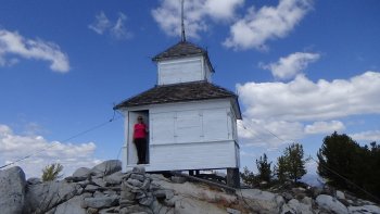
| North Twentymile Lookout (structure exists) | X | X | 48.75098, -120.068338 GPS Track There are two full structures within feet of each other, a tower and a cupula building. The only reason I can fathom this to count as only one is that unlike Leecher and Whitmore, you do not have to search for the second building... |
| Okanogan P.O. (structure exists) | X | X | |
| Old Baldy | |||
| Omak Mtn. Lookout (structure exists) | X | X | 48.44934, -119.30903 My GPS track for this one seems to have gone missing. It was not a hard road to follow |
| Oval Peak | |||
| Pearygin Peak Lookout | |||
| Quartz Mtn. Lookout | |||
| Remmel Mtn. Lookout | |||
| Robinson Pass | |||
| Setting Sun Lookout | |||
| Sheep Mtn. | |||
| Skalawag Ridge | |||
| Skull and Crossbones Lookout | |||
| Slate Peak Lookout (structure exists) | X | 48.7418, -120.6794 | |
| South Creek Butte Lookout | |||
| South Huckleberry Mtn. Lookout | |||
| Stahley Mtn. Lookout | |||
| Strawberry Mtn. (Colville BIA) Lookout (structure exists) | X | X | 48.45168, -118.93748 GPS Track |
| Strawberry Mtn. (Okanogan N.F.) Lookout | |||
| Sweetgrass Butte Lookout | |||
| Taylor Ridge Lookout | |||
| Thirteenmile | |||
| Thrapp Mtn. Lookout | |||
| Tiffany Mtn. Lookout | |||
| Togo Mtn. Lookout | |||
| Tunk Mtn. Lookout (structure exists) | X | 48 32.725, -119 14.180 | |
| Twin Sisters | |||
| Vulcan Mtn. | |||
| Wapaloosie Mtn. | |||
| War Creek Ridge Lookout | |||
| Washington Butte Lookout | |||
| White Mtn. Lookout | |||
| Whitestone Mtn. Lookout (structure exists) | 48.02173, -118.50943 | ||
| Whitmore L-4 Cab Lookout Site (structure exists) | X | X | See the next entry for some description. The L-4 cab was almost due east of the end of the GPS track. The tower location is marked on the map. |
| Whitmore Mtn. Lookout (structure exists) | X | X | 48.18018, -119.24706 GPS Driving Track (The driving directions we had for this location were flawed.) This site, with two structures is counted as two on the list of 93. |
| Windy Peak Lookout | |||
| Winthrop (Stud Horse) |