We have now both been to all of the sites with structures in this zone. Nothing changes with this as I adopt the Peakbaggers list
Stats without AWS Adjustments
| Total Sites: | 64 | Sites with Structures: | 6 |
| Kari has visited: | 22 | Kari has visited: | 6 |
| Dave has visited: | 14 | Dave has visited: | 6 |
| Lookout Name | Kari | Dave | Comments |
|---|---|---|---|
| Alpine (Nason Ridge) Lookout (structure exists) | X | X | GPS Track |
| Badger Mtn. Lookout | |||
| Baldy Mtn. | |||
| Basalt Peak | 47.9762, -120.7484 | ||
| Beehive Mtn. Lookout | |||
| Big Hill Lookout | |||
| Boulder Butte | X | ||
| Boundary Butte Lookout | We attempted this one south of Leavenworth. The logistics of this hike are more complicated than it would first appear. See this GPS Track for two possible routes. We attained the ridge for a scramble approach from the north. It looked easy but somewhat brushy and it was too wet on that day. The other way as marked on this map goes all the way around for an approach from the south. | ||
| Byrd Point | |||
| Carne Mtn. Lookout | X | X | 48.0884, -120.8030 GPS Track |
| Chelan (Sagebrush) Lookout | |||
| Chelan Butte Lookout | |||
| Chumstick Mtn. Lookout | 47.6506, -120.4511 | ||
| Cougar Mtn. Lookout | 47.8912, -120.5813 | ||
| David | |||
| Davis Peak | X | ||
| Dirtyface Ridge Lookout | X | X | A lookout site above Lake Wenatchee GPS Track |
| Domke Mtn. Lookout | |||
| Duncan Hill Lookout | |||
| Easton Ridge Lookout | X | X | |
| Elbow Peak | |||
| Estes Butte Lookout | 48.0188, -120.7924 | ||
| Fish Lake Lookout | |||
| French Ridge | X | ||
| Goman Peak | |||
| Goode Ridge | |||
| Harriets Peak Lookout | |||
| Horton Butte | |||
| Icicle Ridge Lookout | X | X | Although there is a faster route up Fourth of July trail. We did a three day backpack of the entire ridge. GPS Track |
| Jack Ridge | |||
| Jolly Mtn. Lookout | X | Winter scramble routes. There are four tracks pictured. The single track is the one I recorded. The file with 3 tracks is from other sources. | |
| Junction Ridge | |||
| Junior Point Lookout | |||
| Keystone Point | 47.6362, -120.2813 | ||
| Klone Peak Lookout | 47.9618, -120.6210 | ||
| Koppen Mtn. | X | X | |
| Lion Rock Lookout | |||
| Lookout Mtn. | |||
| Lorraine | |||
| Margaret | X | X | Winter scramble route |
| McCue Ridge | X | ||
| McGregor Mtn. Lookout | |||
| Mission Peak Lookout | X | ||
| Naneum Ridge Lookout | X | ||
| Nelson Butte Lookout | |||
| Poe Mtn. Lookout | X | ||
| Polallie Mtn. Lookout | X | X | Done as a side trip on a Backpack to Waptus Lake GPS Track |
| Pyramid Mtn. Lookout | |||
| Red Mtn. | |||
| Red Top Lookout (structure exists) | X | X | GPS Tracks There are two good routes to this lookout. We did enough of both to include them here. |
| Rock Mtn. Lookout | X | ||
| Slide Ridge | |||
| Soda Springs | X | X | GPS Track |
| Stafford | |||
| Steliko Point Lookout (structure exists) | X | X | 47.74062, -120.34425 GPS Track While this is a road hike with no gate. A very high ground clearance vehicle (and a bit of crazy) is required. |
| Stiletto Ridge Lookout | |||
| Stormy Mtn. Lookout | |||
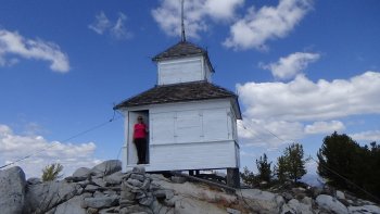
| Sugarloaf Mtn. Lookout (structure exists) | X | X | 47.756825, -120.527704 GPS Track Drive most of the way with a high ground clearance vehicle |
| Teanaway Butte Lookout | X | ||
| Thorp Mtn. Lookout (structure exists) | X | X | A Backpack along Kachess Ridge and to the Thorp Mtn Fire Lookout GPS Track |
| Three Brothers Lookout | |||
| Tiptop Lookout | |||
| Tumwater Mtn. | 47.6297, -120.7072 | ||
| Tyee Mtn. Lookout (structure exists) | X | X | 47.863954, -120.471109 GPS Track (Trail) Drive with a high ground clearance vehicle or hike the trail |
| Vie Mtn. Lookout |